Make Way For The Freeway
 You won’t find the Rose-Blanshard district on any 21st-century map of Victoria – but that doesn’t mean that it should be forgotten. Fifty years ago, the area north of the Memorial Arena, between Bay and Hillside, was a neighbourhood of small wooden houses built between 1890 and 1910, and carved into cheap apartments. But in the 1950s the City of Victoria, like many municipalities in North America, became interested in “urban renewal” programs, which maintained that crime and delinquency could be eradicated if “slums” were torn down and replaced with modern subsidized housing – and Rose-Blanshard became the city’s target.
 (At left is a map of how the area's laid out today, and how it appeared in the 1960s, when Rose and McBride streets still existed. Thanks to John Bryant and Western Geographical Press for letting me use these images.)
Was Rose-Blanshard really a slum? Its houses were certainly old, but many who remember it say the district was mainly occupied by pensioners and working-class Chinese, Polish, and Italian families. “It was one of the most cohesive neighbourhoods we had,” says Niels Knudsen, who worked for the city’s engineering department at the time. Rose-Blanshard, he says, was a place of weddings, street parties, boulevard trees, and backyard vegetable gardens. “Considering the rest of Victoria, it wasn’t substandard. It was where you started in Canada. It was affordable housing.”
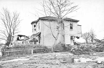
The city had different ideas. In 1961, the Capital Region Planning Board named Rose-Blanshard as the blighted area in the city most in need of urgent renewal, and listed nine reasons for the decision. Number One: “It contains a high concentration of the worst quality houses which are beyond rehabilitation.” Number Nine: “There is a need for low-rental housing.” Most telling were Numbers Three and Eight: “A major road, Blanshard extension, is required through the area,” and “When Blanshard links with the Trans-Canada and Patricia Bay highways, a new demand for motor-hotel use will be created in this area. Small lot ownership would hamper private land assembly.” The city applied for federal and provincial funding for the renewal scheme, and in 1967 it got underway. The city contracted a retired navy commander, Harold V.W. Groos, to be its “information and relocation officer,” and his men went house-to-house, clearing out the neighbourhood. They offered owners a paltry $5,000 for their properties – and if tenants refused to leave, officials took crowbars to the doors (photo right) and evicted them. Over the next two years, the city bought and bulldozed more than 100 homes.
The city did build some new social housing: in 1970, it opened the Blanshard Court project, and the 184 units quickly filled up with grateful people who’d been living on social assistance. But that benefit had come at a considerable price. According to a 1973 UVic study, the pensioners and families who’d been forced out of Rose-Blanshard had to pay an average of 40% more for rent in their new residences. And much of the vanished neighbourhood, of course, is now occupied by a six-lane thoroughfare lined with strip malls.
PS A fascinating 1964 film about a similar urban renewal program in Vancouver is posted on Gordon Price's blog here.
posted by ross @ 11:47 AM
![]()
![]()


15 Comments:
Anyone know where I can find more info about the public housing that was built (who designed, etc...)?
Most of the info and photos in this piece came from "Anatomy of a Renewal Scheme", in Residential and Neighbourhood Studies in Victoria (edited by C.N. Forward, 1973), a book available at the Greater Victoria Public Library.
Unfortunately, I just looked through the book, and it mainly talks about the relocation of the previous residents, not about the buildings there today. So try the City of Victoria archives: start with their newspaper clipping file on "Development & Planning - Rose/Blanshard Street", or the Town Planning Commission Records, 1951-1965 (CRS 31). Good luck!
I wish I was taught more local history in school. It wasn't until college that I was able to take a course in BC history. There is a place for the Egyptians, Aztecs, and Mayans but it seems silly to overlook places and people that can actually be visited within walking distance or a short bus ride. I think if more people learned about their local history they might actually care more about where they live.
Jebby, I agree completely! Thanks for reading the blog.
I worked with a community advocate at the Together Against Poverty Society (TAPS) here in Victoria who grew up in the Mayfair Mall area. She described it as a working class area, with a lot of what I would call "light industry" - small manufacturing - in the area. Mayfair Lanes bowling alley was a vestige of that community. Interesting post.
This is also of interest to me, as I stayed with friends on Rose Street just south of Hillside Ave. for several months c. 1952, which is now known as Blanshard St. The homes were well maintained and it was a decent neighbourhood. It was only after they built Blanshard Court that it became a slum.
Not far from there was an ice company, who delivered ice to private homes for the ice boxes to keep food fresh. The ice boxes were generally kept on people's back porches. I remember the big ice picks and how the "ice man" hoisted the huge blocks of ice onto his burlap covered shoulder.
In the 1940s the brickyards were located where the Mayfair Mall is now situated and included the lower part of Topaz Park along Finlayson and what is now Blanshard Street. The latter was a wonderful place for us kids to play in all that wonderful clay!
As well, the ruins of the old gaol were once where S.J.Willis is now situated. What fabulous memories of playing there. We also had the run of all the open fields surrounding the area and later attended S.J.Willis School c. 1953-55.
Marilyn
(a 4th generation Victorian)
For some reason I remember a campsite around the mayfair mall area in the early 1960s does anyone recollect?
What freeway? Blanshard has never been a freeway.
Blanshard sure sounds like a freeway when your house faces onto it! :-)
I lived in evergreen terrace in the mid 2000s
The Victoria Ice Company mentioned and the Baker Brick And Tile Company located where Mayfair Mall is now we're both owned by Stanley Baker
Thanks Marilyn for the memories, the old houses along Hillside, the brick works where I played as a child and SJ Willis Jr High (1962-65).
I lived in the blanchard courts for 10 years and it is one of the city's main roads. It was quite loud but not as busy as a freeway.
Yes they put in a RV park beside the new Blanshard st. Roadway. They cut the road I lived on Shamrock st. And it ran from Oak st and was a dead end where the old glass green houses were, if you drive up Blanshard towards Saanich road where the plumbing store is just before BCBC building there is a huge rock face that was blasted, that was where Shamrock st ended and the farmers field started, and the RV park was the entire block from Cloverdale Blanshard and Seymour almost up to Saanich rd. That area was so much different back then with houses on both sides of cloverdale from Douglas st right up to Quadra st. It was a great place to grow up before the highway was pushed through and all the houses were torn down.
They made the choice to make Blanshard st. The new highway to get out to the airport and ferries because the old way was from Douglas st. And the two highways of Pat Bay and Trans Canada Highway intersected but in a very insafe manner. The Pat Bay came to a stop at The start of TCH in front of The old town and country mall so you had to came to a stop and cross the outbound lane of the TCH then you moved inbetween the outgoing and incoming lanes of the highway then when safe to do so you could proceed. It was a death trap and had many very seriously bad accidents at that location causing injuries and death. And although it destroyed many homes it ultimately saved many lives.
We moved into the courts when it first opened. The original manager couple were strict but had to be due to teen gangs etc. We moved out a couple of years later as we became delinquents and had to make a change. They were built cheap. We could see into the neighbours basement betwee the main floor and basement plate. There was a camp ground where the old shaw building on Cloverdale was. You could RV there up until 1980ish.
Our family home was in the 2500 block of Blanshard St.and was built in 1951, by my father. Our neighbour, 3 doors down built their home a few years later. We didn't want our homes demolished, so they were moved to Oaklands area, between Cedar Hill and Cook St. Not only did we both move, but are still neighbours, but instead of 3 doors down, we are across from each other with a lane in between.
Post a Comment
<< Home