Bypassing The Malahat
 Maps are as much statements of political ideology as they are representations of physical fact. When I was a kid, growing up during the Cold War, I had a big National Geographic map of the world on my bedroom wall. The odd thing was that it had North America in the middle, and cut Asia in half. China and India were relegated to the edges, as if they were meaningless outlands. But that’s the way American cartographers saw things in 1968.
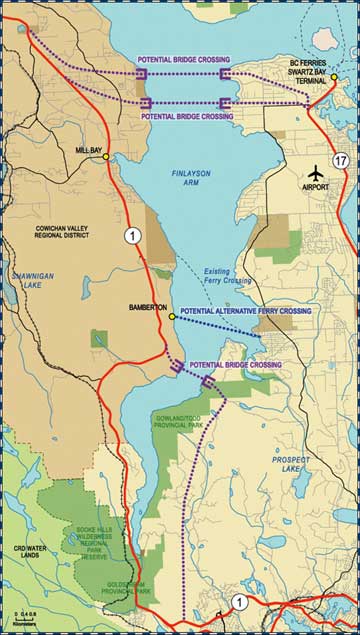
I was reminded of this when I saw the map at left. Last fall, the province hired Stantec to do a $250,000 study finding alternatives to “The Malahat” (page 61 in the book), the narrow section of the highway between Victoria and Duncan that’s frequently closed by high-speed accidents. In December, they posted this map to the study’s website.
As you can imagine, residents of North Saanich were alarmed to see that the consultants are thinking of putting a bridge across the Saanich Inlet, and blasting a freeway through their bucolic district to the Pat Bay highway. In 1997 (see article below right) an engineer proposed a similar bridge, which was quickly shot down by local politicians. (“It’s the most ridiculous idea I have seen in 13 years,” said North Saanich MLA Murray Coell.) And yet the idea is being floated again.
On March 6, the North Saanich council unanimously passed a resolution that the district “strongly opposes” the proposed bridge, and wrote angry missives to the B.C. premier and Stantec, from which they received token, form-letter replies. Now the district’s worried because only one open house for the entire capital region will be held to discuss the project – on Thursday, June 15, from 3:00 pm to 8:00 pm at the Luxton Community Hall, 1040 Marwood Avenue in Langford – a considerable distance from the part of town likely to be most affected by it. The consultants likely selected the open-house location because they’ve also mapped a bridge across the Inlet further south, and proposed ramming a freeway through the Highlands. Though that would benefit big-box Langford and transform the hard-to-reach Highlands into Victoria's next suburban boomtown, I suspect North Saanich has good reason to fear that they’re the ones about to get steamrolled. (The ferry option on the map is a mere garnish, a useless bit of parsley to green up the discussions: no boat is big enough to make a dent in the 20,000 cars that use the Malahat every day.) The whole purpose is to get people faster to and from the Cowichan Valley, and a bridge to North Saanich would provide quick connections to the Swartz Bay ferry terminal and the Sidney airport – all the more necessary since the Nanaimo airport’s expansion plans have stalled on its puny runway.
Then again, the government could improve passenger rail: once the Island Corridor Foundation finds an operator for the Esquimalt & Nanaimo railway, the tracks will need $25 million in upgrades, plus modernized stations. Or the government could simply hire more police to patrol the Malahat, and erect giant signs announcing a $2,000 fine for speeding. But will such car-unfriendly alternatives get serious consideration? I doubt it. They’re literally not on the map. UPDATE (July 17, 2006): North Saanich’s bridge opponents were flustered by the recent appearance of the message at right on a billboard along the Pat Bay highway. Could it be serious? Apparently not. As I mention on page 64 of the book, renting a billboard is an easy way to get attention – and this one is merely a lame attempt to win eyeballs for the upstart ad company that created it. Even the B.C. government has said that a fixed link to the mainland is dead in the water.
If you have comments on the real proposals that Stantec and the government will be considering to improve (increase) traffic on southern Vancouver Island, you have until July 31 to make them. Go here for more information.
posted by ross @ 10:24 AM
![]()
![]()


1 Comments:
They should pave one of the logging roads from Port Renfrew or Sooke to Lake Cowichan. Would solve the "problem" and open up the southern Island. Might even fix Pacheedaht a.k.a. hell on earth...
Post a Comment
<< Home